Geographic Imager for Adobe Photoshop - Floating License and 1 Year Maintenance
Avenza Systems Inc.Product type:
1 - 4 User(s)
5 - 9 User(s)
1+ User(s)
1709.39 CHF
for EU and non-EU countries (except Switzerland) including 0% VAT
1847.86 CHF
for Switzerland including 8.1% VAT
Free electronic delivery - 1-3 working days
Can't find what you are looking for? Contact us through chat widget,
support form
or
email
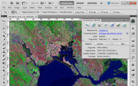
Working with raster imagery doesn't have to be complicated. Geographic
Imager® mapping software enhances Adobe Photoshop to make working with
spatial imagery quick and efficient. It adds tools to import, edit,
manipulate and export geospatial images such as aerial and satellite
imagery. Enjoy the use of native Adobe Photoshop functions such as
transparencies, filters, pixel editing, and image adjustments like
brightness, contrast, and curve controls while maintaining spatial
referencing. Geographic Imager supports GeoTIFF in Adobe Photoshop and other industry standard raster formats.
Mosaic and tile images, change projections, transform, rectify and
georeference images based on ground control points. Batch-process your
imagery using Geographic Imager and Adobe Photoshop scripting
capabilities. Geographic Imager is a great companion to MAPublisher for Adobe Illustrator—prepare images in Geographic Imager and use them in MAPublisher.